Note: This is part 2 of our canoe trip down the Yukon River in August, 2016, from Carmacks to Dawson City.
Fog shrouds the river when I get up but the sun is working its magic and I begin my ritual of making coffee. With our clothes cleaned and our larder restocked there is no reason to stay, so we break camp after breakfast and load the canoe, happy to get back on the river, away from the noise of the road and town. We pull into shore in town at the bridge crossing the river to grab a couple of things we forgot to buy the previous day and soon enough the town is but a memory as the river veers away from the road and all is quiet again.

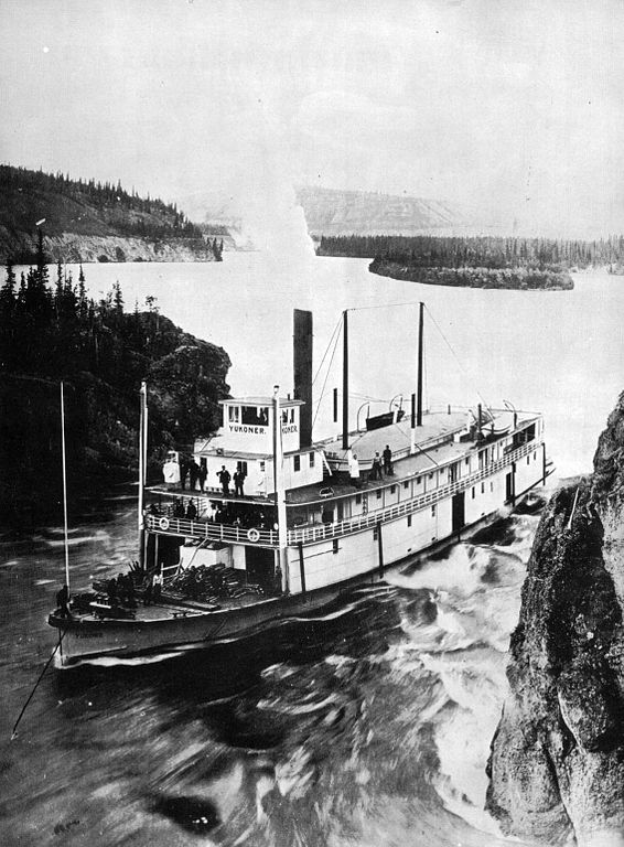
The only significant rapid on the Yukon River is Five Fingers Rapid, named for the five channels created by four rock columns in the river. It looks imposing but is a fast, easy run with only a few small standing waves. We sail through the right channel while tourists high up on the bank take photographs of us.

It’s hard to believe the steamers went through this narrow opening. Blasting during the early years of the gold rush made the right channel wider to make it safer for the steamers. When travelling upstream, the steamers had to be winched through the gap with a 600-metre-long steel cable, installed by the White Pass & Yukon Railway, the company that owned many of the boats. Rink Rapids is a few kilometres further downstream but it’s really just a a fast section of water in a narrowing channel.
The river is big now with many islands and sandbars. We mostly stick to the main channel but often pick smaller ones to be closer to shore and see more details in the landscape. Wildlife, moose in particular, like to hang out on the shores of smaller channels, feeding on the lush deciduous trees on the islands.
A young moose runs after us along the shore of an island, bellowing all the while. I think it’s confused. We don’t look like a moose at all. It was probably separated from its mother while swimming across the river. Perhaps the current was too strong. The moose keeps running after us until it runs out of island and the river carries us downstream.

We make camp at the mouth of Merrice Creek where part of an old cabin is still in pretty good repair. There are others that have collapsed and are rotting away. The door of the main cabin is made from a sign from the Williams Creek Copper Mine, a few miles downstream.


It’s a great camp spot with lots of space for our tent and several fire pits with an ample supply of wood around. A wide trail leads away from the site connecting to an even wider trail running parallel to the river. This was the old Dawson to Whitehorse stage coach road used in winter to transport mail and people between Whitehorse and Dawson. It was a rough journey of up to 10 days and cost $125, an astronomical amount of money back in 1902 when it first opened. There were road houses along the way, spaced about 25 miles apart where weary travellers could get a meal and a bed.
A 100 years ago, a number of small hard rock mines operated in this area, extracting gold, silver and copper but what is proposed for the area today is of a much larger scale. The Copper North Mining Corporation owns what is called the Carmacks Project. The proposed open pit mine is expected to operate for only about eight years and has an estimated mineral value of US$1 billion. There is no cost to the environment in these calculations. But there are even grander and scarier proposals for an area further north along the river.
The Casino copper, gold, silver and molybdenum mine “is poised to be the premier Copper-Gold mine in Canada and the flagship mine for the Yukon,” according to the company’s web site. The numbers are staggering and the impact it could have on the landscape and the Yukon river is the stuff of nightmares. The project is currently in the environmental review stage. The electricity requirements for the project are expected to be 150 MW. The Yukon Energy Corporation currently produces about 83 MW to service the entire territory. Casino’s web site states: “Liquefied natural gas (LNG) will be trucked to the project site and gasified to provide natural gas to fuel the 150 MW power plant.”

A pipeline will need to be built to take water from the Yukon River for mine operations. A dam will need to be constructed to hold the tailings. Ore will be processed on site and the concentrate will be shipped by truck to Skagway, Alaska, where it will be loaded on ships, most likely bound for Asia. The carbon footprint for this project is unimaginable.
The company has a 10-minute animated video on its web site describing the 22-year life of the proposed mine, set to cheery elevator music ironically titled “Uplifting Things.” The idea of such a mine is anything but uplifting. The video describes how the “reclamation process” will leave behind only the (giant and poisonous) tailings pond and the flooded pit mine, creating two lakes where none exist now. What if the tailings dam bursts, like it did at the Mount Polley copper and gold mine in BC on August 4, 2014? The toxic slurry of mud and mine waste ended up in Quesnel Lake and the Cariboo River. Environmental regulations and oversight just aren’t tough enough on mining companies and tax payers are often left holding the bag for clean-up costs, if such spills can actually ever be cleaned up. The north is littered with abandoned mines and exploration camps that never get cleaned up. We try not to think about the possibility of these kinds of risky projects devastating the landscape.

The character of the river has changed. It’s bigger, wider and full of islands and sandbars. We are constantly presented with multiple choices of channels. We navigate small sloughs and try not to get hung up on hard to see sandbars barely submerged under a few inches of water. Stumps and deadheads are the main danger as the water has become murkier as silty creeks and rivers flow into the Yukon.
We take one of these side channels approaching Hell’s Gate. This was a particularly tough part of the river for the steamers to navigate. Many of them got hung up on the bars. It’s a long, wide section of river with several dozen islands and bars, creating side channels and sloughs, redirecting water from the main channel. As early as 1902, work began to improve the channel but I imagine it was a frustrating and futile task to make this river go where it didn’t want to go. Wing dams were built and the channel was dredged year after year. An 800-metre-long cable was needed to line boats through a fast section but the current was so strong that boats were drawn into side channels. And then the winter ice would wreak havoc with the dams during break-up each spring. There is almost no evidence of that painstaking work.

We camp at Hell’s Gate (Blanshard’s) Wood Yard. There are several crumbling cabins and old trucks at the site, as well as the remains of a boat on shore, and there is a wide trail that connects to the old stage coach road. Late in the evening, we suddenly hear voices. As we stand up a canoe comes into view and then another and another. It’s a group of 15 in seven canoes, paddling from Carmacks to Dawson. We greet them and they ask us if we know where Thom’s cabin is and we tell them they passed it about 15 km back. They paddle on in the failing light.


We run into them again the next day and together we paddle on to Fort Selkirk. It turns out the group’s leader, Jeff, is a man Jan worked with a number of years ago. What a small world. He tells us he has another group on the river about half a day ahead. We explore Fort Selkirk and have lunch there. Parks Canada has been pouring money into preserving the site and most of the buildings, including cabins, two churches, a store and a myriad of other buildings, are in good condition.

Fort Selkirk sits on the high banks of the west shore of the Yukon, opposite where the Pelly River flows in. The Northern Tutchone used this area for untold generations and it wasn’t until the 1840s when a Hudson’s Bay trader, Robert Campbell, first came into the area and established a trading post. But there was already a well-established trade network in place run by the Chilkat people from the Alaska coast and they considered the HBC unwanted competition. In 1852, the Chilkat looted the fort and burned it down. It wasn’t until the 1880s when white men returned to the area to prospect, and the trading post was re-established. The HBC eventually ended up back on the site in 1938 but only until the early 50s when it closed down for good.

The gold rush was the beginning of the end for the Chilkat trade routes that ran from the Alaska coast near Haines over Chilkat Pass to Fort Selkirk and south to Five Fingers Rapid. An American trader by the name of Jack Dalton took possession of the trail in the 1890s and began improving it. He charged a fee for any one using the trail, and for every pound of material transported on “his” trail, except “natives with a light pack were free,” according to Mike Rourke’s Yukon River guide, an excellent publication and a must-have for any river traveller.
The White Pass and Yukon Railway from Skagway to Whitehorse put an end to Dalton’s enterprise in 1900, but considering how much cattle and goods were transported on the Dalton Trail, Jack Dalton became a very rich man. A highway was named after him and he’s held up by historians as one of the pioneers who opened up the country. He’s also in the Alaska Mining Hall of Fame, a veritable who’s who of white people. I have a slightly different view of Dalton’s enterprise.


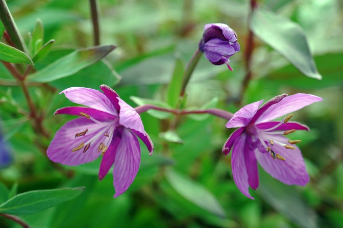
We leave Fort Selkirk after a few hours of exploration to continue our journey. Fall colours are beginning to colour the landscape. Clumps of yellow aspen dot the hillsides as we pick our way through the islands and past Victoria Rock, Ralston Woodyard, Whalens Island and 17 Mile Creek where we find a well used camp site on an island in the middle of the river. Some time later, we hear them before we see them. Amazing how sound carries. Jeff and his group glide past below the yellowing aspen on the opposite side of the channel. They disappear quickly in the fast current. We enjoy the solitude and make a small fire as a rain shower tries to dampen our spirits, to no avail.


The morning is foggy and cold. I revive the fire and make coffee while waiting for Jan to get up. While we sip our first cup, the unmistakable sound of a helicopter fills the air. It’s flying low and circles back over our camp and then slowly descends to the clearing at the upstream end of our island, about 200 metres from camp. We walk down the shoreline trail and are met by an RCMP constable who asks us if we’ve seen a red canoe with two people. He tells us they were separated from their group the day before and were last seen in this area and reported missing. They belong to Jeff’s other group. We promise to keep an eye out and the policeman returns to the chopper. Moments later, it’s in the air again trying to find a needle in a haystack as the fog closes in.

We are barely on our second cup of coffee when the chopper returns. The RCMP informs us the missing party has been found. He wanted us to know so we wouldn’t go out of our way to look for them. Having been the fortunate recipient of the RCMP’s assistance in an emergency 8 years ago in the Chilcotin in BC, it’s nice to know people still come looking for you when things go sideways.

Happy the lost paddlers are reunited with their group somewhere on the river ahead of us, we make breakfast and go through our usual routine of packing up. The fog has all but disappeared when we head out. We stay out of the main channel, preferring smaller side channels, hoping to see wildlife. We’re in luck. A black bear is swimming across the river just ahead of us. We quietly approach but keep a respectful distance as we take some photos.

The bear is a strong swimmer. As it approaches the shallows, I’m amazed at how deliberately and carefully the bear places its paws, slowly emerging from the water, it’s black coat glistening in the sun. We still haven’t been spotted despite floating past. The bear slowly walks through the mud, turns its head and sees us. It immediately bolts in an explosive movement and disappears into the forrest. I’m always happy to see that kind of reaction. It means the bear has a healthy respect for humans, minimizing the chances of an unwanted encounter.
We float through the day, basking in sunny solitude. By mid-afternoon, we usually begin scouting for a campsite. It’s surprisingly difficult, sometimes, to find a place. The banks are often overgrown and we have some basic requirements a camp site must have: open space for light, enough flat ground for the tent (obviously), and preferably, a view and sun exposure. Today’s offerings are minimal. The banks on one side are thick with bush and rise steeply on the other side. We cross the channel to try our luck. As the current pushes us along and across, we spot a faint trail on the steep cut bank. We land and climb up to find a well-used camp site with a clearing, a large fire pit and trails heading off in both directions. It’s not the easiest spot because of the high, steep cut bank but it ticks off all the boxes, so we unload and haul the gear up. We find a small ledge close to the water for the canoe and tie it to a large log stuck on shore. I always tie the canoe to something after nearly losing my canoe on a trip many years ago.

We love having so much time. This far north, the days in August are still long with the sun setting around 10 p.m. We usually try to get off the river by 3 or 4, giving us several more hours of daylight to while away the day. The sunsets last much longer, too, bathing the land in orange light as the day slowly turns to night. We have been keen to see the aurora borealis but haven’t had any luck, partly because we have a hard time staying up until it’s dark enough. I usually get up in the night and always look up, marvelling at the stars and the milky way while answering nature’s call, but the aurora remains elusive.

The weather changes over night and in the morning the day promises to be a gloomy one. It deteriorates quickly and we silently paddle in the rain to Kirkman Creek where there is a homestead offering camping and a bakery. The thought of a piece of pie and a hot coffee keeps us motivated. We arrive around midday and walk up into a ramshackle collection of buildings, machinery and junk. Laundry hangs on a line in the rain. I wonder if that’s a way to wash it or if it was just forgotten. There is no sign of life, other than a friendly dog.

There is a house further back on the property with smoke coming from the chimney, so we walk up there and knock on the door. We are greeted by a rather unfriendly woman and more dogs. We ask about coffee and pie and she grumbles something I don’t catch. She puts on her boots and leads us back to the bakery. We try to engage her in conversation but without success. We buy a loaf of bread and have our pie and a putrid cup of liquid disguised as coffee in the shelter of a small gazebo. We would have camped there because the weather was quite nasty but we prefer paddling in the rain to spending the day at such an unwelcoming place.

It’s a long day. It’s cold and the rain doesn’t stop until late in the afternoon. At Thistle Creek, we slip into a small side channel, hoping to find a place to camp. It’s a gorgeous, lush forested area with sloughs and dead ends. We come upon a cow moose standing in the water. We stop paddling and just float by. It’s so big. She slowly walks back to shore and we hear her thrashing through the bush as we paddle on. No camping.
We’re now approaching the White River. Just as we enter the braided channels of the confluence of these two large rivers, I spot a cabin on an island to our left about 200 metres across the channel but we are past it already. I tell Jan and rudder the stern around to turn the canoe into the current, setting us up for a tough upstream ferry. We paddle like two people possessed and it’s not immediately clear if we are going to make it. The current is formidable but slowly we inch across the channel without losing ground and eventually manage to get into the slower current behind the island. Finally, we make it across to the island and land below the cabin.

It is small but well built and there is enough space to pitch a tent in the trees nearby. We don’t like sleeping in cabins but we will use them to get out of the weather. There are three cots inside, a chair and table, some pots and pans and a barrel stove. One window is shuttered but the other is not and the plastic covering is torn where an extension cord has been put through. It’s obvious this cabin is used regularly. Other paddlers have been here, too, over the years. We read their scribbled notes and dates on the wall by the door. I’ve never understood people’s desire to make their mark in these places. We are grateful for the shelter. There is no fire wood but inside the cabin, with our stove going to make dinner, it’s fairly warm and we dry out after a long soggy day. We’ve paddled 62 km. For dinner, we make a big pot of noodle soup with whatever else we can think of thrown in. Tired, we collapse in the tent while more rain falls most of the night.

The sun greets us in the morning. It’s a bluebird day. Our soggy stuff has dried out. Until now, we’ve mostly taken water from the Yukon and sometimes from creeks flowing into it. Now that the White River has joined the flow, we have to get our water from creeks. The White, aptly named, is a big river originating in Alaska’s Saint Elias Mountains. It carries so much silt that it turns the Yukon the colour of coffee with milk for the rest of its course to the Bering Sea.

The silt also creates many more islands and sandbars in the river. There are many shallows with snags and logs stuck in the mud. The ones I can see don’t worry me. It’s the ones just below the surface that pose the greatest danger. Hitting one in the fast current can upset a canoe fairly quickly. We keep a vigilant eye out for tell-tale ripples.

The change in weather has not only brought the sun. A stiff headwind has come with it. After 30 km paddling into the wind, trying to no avail to find shelter in smaller channels behind islands, we finally give up and camp on a sandbar in the protection of a clump of willows. For the second time on this trip, we are marooned by good weather.

But we don’t mind as we are under no pressure to make miles. We spend time photographing, read our books and just enjoy the luxury of time. The wind dies down later in the day and as the sun hangs low in the sky we circumambulate our willowy perch in the middle of the river, finding human foot prints in the sand on the other side of the island, destroying the illusion of being solitary travellers.

Our journey is coming to an end and, as always, we reluctantly move closer to our destination. I could just keep going on this river. It’s easy travelling. The current does most of the work, allowing us to enjoy the scenery and let the mind wander freely across its inner landscape. It’s such an amazing experience to travel in these wild places and I wonder why not more people do. But then I acknowledge I’ve arranged my whole life to do these kinds of trips, and I will never deny it truly is a privilege to do this.

We have a long, lazy morning and don’t get on the river until 11. We pick our way along this elongated archipelago, choosing to stay mostly in the main channel now as the smaller ones tend to be shallow and we don’t want to get stuck in the mud. We set our sights on Meachem Creek, 45 km south of Dawson City, and we arriver there late in the afternoon. It’s another well-used encampment. After pitching the tent and organizing the gear, we hike up the trail to find the remnants of a cabin. Our guide tells us it may have belonged to one John Scholtz who applied for a homestead here in 1912.


We make dinner and sit by the fire as the light changes into the long, drawn out golden hour. Tomorrow, we will arrive in Dawson City but tonight we are thankful for one more night on the river as I drink the last beer and Jan sucks the dregs from the wine bag. We rationed our supplies well.

The last day on the trail is always one of mixed feelings. We look forward to the hot shower, pampering ourselves in a good hotel, and eating something other than pasta with stuff, or rice with stuff, or noodles with stuff. On the other hand, there is always a feeling of loss when ending a journey. Loss of freedom. Loss of solitude. Loss of this precious time together in a world that increasingly encroaches on wild places.

We float into Dawson by early afternoon, landing on the public dock. We consolidate our gear and find out where to leave the canoe. The outfitter offers to drive us and our stuff the few blocks to our hotel and we gratefully accept. Dawson City is still very much a frontier town. It looks a bit like a movie set with its false front buildings and a lot of effort has been put into preserving the feel of the gold rush days of a century ago. It’s hard to believe this town of about 1,500 was once a bustling city of 30,000 people hoping to strike it rich in the Klondike. Some did but many failed.

We check into our room at Bombay Peggy’s, a former whorehouse and bootlegging joint that was rotting away on the edge of town before the current owner, Wendy, moved it to its current site and restored it. It’s now a nine-room hotel and pub where a modern-day traveller can rest his head and have a drink. There are no prostitutes any longer but the cocktail menu creatively ties into the building’s history as a brothel.

We spend the afternoon and the next day exploring this northern outpost before boarding the 5 p.m. flight back to Whitehorse on a plane that’s probably older than we are. Our bicycles await us in Whitehorse. Olivier and Katie, our amazingly generous Warm Showers hosts there, have stored them for our next part of our journey.


I’ve only ever taken one multi day canoe trip, and have always wanted to go for another. What a great adventure in both nature AND history. Bonus points for rationing the most important supplies, and excellent photos!
Thanks, Tony. I’ll check out your blog. – Pv
Love the Latin. And the dance.
Magical.
I like those old remnants of a past life, great pix.
Thank you.
finally a chance to read and savour the posts and photographs of your amazing trip… your blog takes me there-thank you! You should put it all in a book…of course, there would be several books-all the better!