Some people have asked about how we use our GPS on the road, and what maps we use. So here is a brief explanation.

The GPS we have is a Garmin Etrex 30. It’s small, light weight and cyclotouring friendly. The only downside is the small screen but having a larger unit would not work all that well on the bicycle, I think.
It attaches to the handle bar with a simple mount, available as a separate accessory. We bought this from Mountain Equipment Coop in Vancouver. It comes with a couple of very basic maps installed but those are almost completely useless, especially for cycle touring. The cost of this GPS is $259.
It seems to be completely weather proof as it’s been on the bike for months now in all kinds of rain and weather and has shown no ill effects from this. Just make sure the rubber usb cover on the back is tightly closed.
Garmin offers software for the computer called Basecamp that is free to download from the Garmin web site, or the Apple App Store, if you’re a Mac user. Garmin also offers free software and firmware updates for the GPS. This is done automatically every time you connect it to the computer when you have an internet connection.
I won’t go into the details of how to use the GPS but this particular one is pretty intuitive, as are most of them. To learn the particulars, using it is the best way to learn. There are all kinds of tutorials available online.
Garmin sells a wide variety of maps but they are expensive and there really is no need to fork out heaps of money for these as there is a great online service for cyclists that provides free custom maps for Garmin GPS units. I suggest you make a donation to them instead of shelling out your hard-earned cash to Garmin.
OpenFietsMap.nl is a Dutch web site that offers very detailed maps of Europe, specifically for cyclists. As more countries release their mapping data, more detailed maps will become available. The best thing about these maps is that they are “routable” meaning that you can design a route and upload it to your GPS and follow it to your destination.
The other nice feature of the maps is that they come with a lots of information embedded. Things like shopping, accommodation and transportation are available by pushing a few buttons. For example, if you’re looking for a grocery store, it will display which ones are nearby, how far away they are and in which direction. Select one and ask the GPS to give you directions, and you’re on your way. We used this feature repeatedly to find shops, camp grounds and hotels. It worked without fail and got us to the desired spot every time.
On the Open Fiets Map site is a page called “Worldwide” where you can get a map of any country. The detail on these maps is not as great as the European country maps from the main page, but they are very usable.
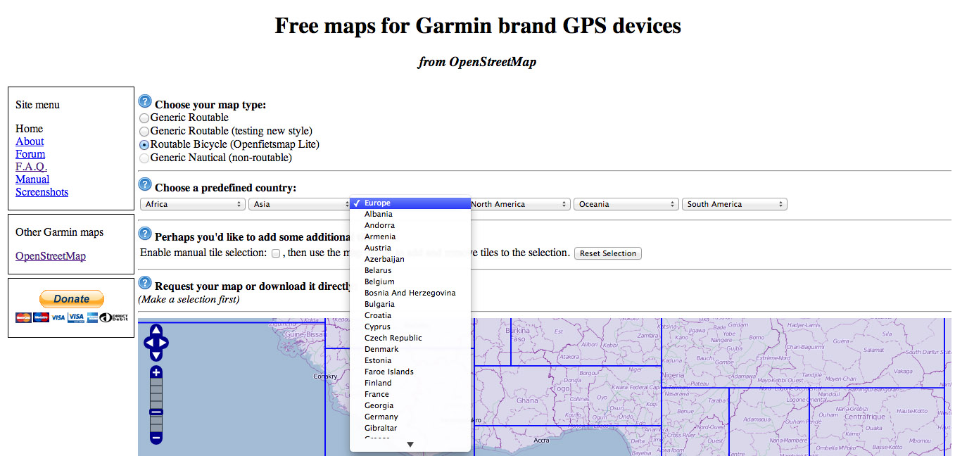
The key is to select the radio button beside “Routable Bicycle” and then use the drop-down menus of the five continents to select your country. The map below then displays the map tiles that make up the country you selected. Below is a screenshot of the complete map for Turkey. To the left is a list of tiles that make up the map.

Most of the time you can then download your map immediately by clicking the download link which will take you to a page where you download the various files you need: one for the GPS and one for the computer. An explanation of the files is to the right in case you’re not sure which files you need to download. The files you download are different for Mac, PC or Linux, so make sure you get the correct file.

If you want only a map of part of a country you can make a custom map by clicking the box beside “Enable manual tile selection.” Then you can click through the tiles on the map to select your desired tiles. Once you have finished your selection, the system will ask you to enter an email address so you can be notified when your map is ready for downloading. This sometimes takes only minutes but if there are many requests it can take longer. Once you get the email, click on the link which takes you to the download page where you can download the ‘gmappsupp.img’ file for the Garmin and the ‘.gmap’ file for Basecamp. The files can be large so you need a stable internet connection and some time.
The files are .zip files and you will need an extractor to open them up. On the Mac, use The Unarchiver, downloadable for free from the App Store or here. Make sure you open the files in the same folder where the zip files are stored. Connect the GPS to your computer and transfer the ‘gmappsupp.img’ file to the GPS and install the ‘.gmap’ file into Basecamp. The GPS has a slot for a micro-SD card which you will need to have multiple maps installed. I have a 2-GB (the maximum) card in the GPS and you just drag and drop the file onto the card to install it. The next time you start the GPS, the map will be the one displayed. To install the other file into Basecamp you need to use MapManager which comes with Basecamp.
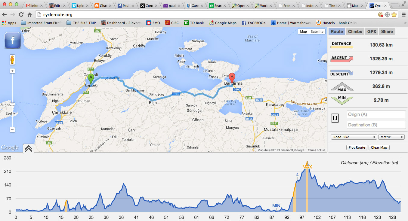
The other useful tool with the GPS is another web site: http://cycleroute.org/ where you can enter your starting point and end point and it will display a map of a route, along with details of distance, ascent, descent and minimum and maximum elevations, as well as a graph showing elevation changes. It’s a helpful tool in planning your day.
I imagine there are many other maps and GPS units but this is what we have been using and it has worked very well for us in combination with a paper map for overview and refernce. We try to get a free map from tourist info offices or just buy a cheap road map. The Etrex 30 uses two AA batteries which usually last 4 or 5 days. I use rechargeable lithium batteries that can be charged with the bicycle’s dynamo hub.

Great to be kept informed along your cycling-journey. Thinking of you often.
Happy New Year which you will be marking hours before us.
Tomorrow we plan to go to government house for the L-G annual levee (but not in a chevie). 🙂
David
Great information, Paul — thank you!
Just headed out from Sao Vincente (north coast) to see the ‘world famous, Guiness world record’ fireworks in Funchal (south coast) – tunnels make for quick travel. Think it might be a touch busy down there, but what the heck?! Happy NYE to you too!